How the Battleford Trail shaped Saskatchewan’s growth
Wagons, stagecoaches and ox courts used to travel the Battleford Trail between Swift Current and Meadow Lake.
The roots of Saskatchewan’s north-south connection trace back to a humble beginning — a rugged wagon trail that once linked Battleford to the broader prairie landscape and helped shape the province’s early growth.
The Battleford Trail, as it became known, was the main connecting point for supplies for those traveling to and from Battleford. The trail connected the Swift Current region in the south to Battleford and the Meadow Lake region in the north.

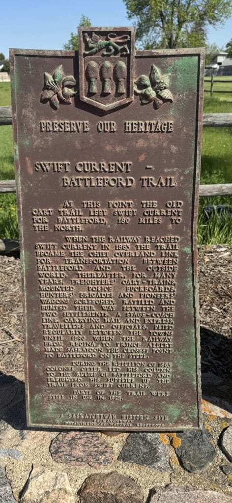
The most famous section of the trail is the 300 km trail from the south, known as the Swift Current-Battleford Trail. This was an important link developed in the late 19th century for transportation and communication between the settlements of Swift Current and Battleford. The trail began with a brisk trade in buffalo bones, which resulted in heavy traffic between the two regions.
Due to the large volume of Red River cart traffic, the ruts created a still-visible path. Soon, it became not only Red River carts but also a variety of wagons, loaded down with supplies, that brought much-needed items from both the north and the south to Battleford, one of the biggest settlements at the time in the area that would become Saskatchewan.
Local, independent, in-depth.
Our Prairie stories.
Ox carts, teams, wagons, stagecoaches, and mail carriers used this trail as it crossed the southern portion, headed into what became the Saskatchewan Landing. The trail was eventually regularly policed from 1876 by the R.N.W.M.P. By 1883, the southern railway had reached Swift Current, and the trail became an even more important link between Battleford and the outside world.
In 1885, the Riel Rebellion saw Colonel Otter and his men use the trail to reach Battleford. In 1886, R.C. Laurie, D.L.S., officially surveyed the trail laid out by G. Marchand in 1883. The construction of a railway between Regina and Prince Albert via Saskatoon in 1890 soon made Saskatoon the closest railway to Battleford and signaled the end of the southern portion known as the Swift Current-Battleford Trail.
However, the northern route, the Meadow Lake portion of the Battleford Trail, remained active until the 1930s. It became the main connection, serving as both an economic and social lifeline for the inhabitants. The Native People, the Métis, and the men of the fur trade were the first users of the trail between Battleford and Meadow Lake. As settlement increased, it was used by the North West Mounted Police and by homesteaders well into the 20th century.
During the Depression years of the 1930s, settlers from the drought-stricken areas of the south followed this route to the north. This included my grandparents, Chris and Jennie Schwartz, who headed north from the Hodgeville region to the area just north of Meadow Lake to seek a better way of life. However, as society and travel evolved, the coming of straight, surveyed roads for this area caused this trail, too, to fall into disuse and be gradually obliterated by the plow.
While those who rode the trails are long gone, we shall remember them. Two markers, one in Swift Current and the other by Meadow Lake, represent those who headed south to meet the world and those who headed north to join them. The Battleford Trail became a provincial heritage site in 1982.
This story was originally published in The Shaunavon Standard. It is republished under a Creative Commons license as part of the Local Journalism Initiative.
Our Prairie stories matter too.
The Flatlander takes a closer look at the stories that unite us, and make us unique, in Saskatchewan and Manitoba.
Will you help us tell our stories?